Conventional Land Surveying
Conventional Land Surveying
The company Skala 3D built its foundations on conventional measurements still before the “GPS era”.
We have large experience both in providing typical surveying services and in fulfilling non-typical orders, according to the client’s needs.
Our offer includes:
- subdivisions and boundary surveys;
- setting out of structures and utility service lines;
- as-built surveys (comprehensive surveying documentation);
- reestablishment of boundary marks;
- surveying services for construction projects;
- displacement monitoring;
- maps for design purposes;
- topographic maps.
Surveying services for construction projects
We provide surveying services under different types of construction projects: housing development projects, road and rail construction projects, and utilities infrastructure projects. We have state-of-the-art equipment, complemented with the use of modern processing technologies.
The scope of our services is always based on an individual approach to the client’s needs. Our conventional services include the following:
Our conventional services:
- surveying services for high-rise housing projects
- surveying services for single-family housing projects
- surveys of overhead crane tracks
")
")
")
Monitoring of Displacements and Deformations
By making periodic scans of a given object, it is possible to determine its geometric condition in time or the level of potential deformation of steel structures, machines, mechanical parts, subassemblies and other. In this way, we can determine the spatial distribution of deformation. The conventional methods do not provide such possibility. They are based on the determination of changes in control points, which gives a very general representation of an object. Laser scanning, on the other hand, provides a highly accurate spatial projection (up to millimeters) which allows us to perform any differential analysis and identify zones that are particularly prone to shape, location or deflection changes.
What does scanning guarantee?
- ASSESSMENT OF THE CONDITION OF AN OBJECT
Structure geometry, foundations. - DAMAGE MODELING
The level of corrosion and areas with significant damage can be measured quickly – this allows us to estimate the degree of degradation of the object and its expected lifetime. - DEFORMATION MONITORING
Assessment of changes in objects over time. - REDUCED NUMBER OF PERSONNEL REQUIRED
Reduced number of persons involved in measurements. - AUTOMATION
Automation of measuring and diagnostic operations. - MILLIMETER ACCURACIES
Accuracies in the order of 1-2mm
- NON-INVASIVENESS
Scanning offers the best alternative in the market to traditional nondestructive testing methods.
- ECONOMIC BENEFITS
Sufficiently early diagnosis may prevent a potential collapse of a structure.
")
")
")
")
Maps for Design Purposes
A necessary element of almost every construction project is a building permit. An obligatory part of this process is to create a map for design purposes, which is covered by the provisions of surveying law. Such a map is prepared by updating the topographic map and at the same time it is to serve as the base map on which a design will be based. To make such maps, we use various technologies according to the accuracy requirements. The output format primarily depends on how the principal maps are represented in the relevant surveying and mapping center or on the client’s individual preferences. As the final product, we provide to the client a map in analog or digital form in CAD format.


Topographic Maps
We make topographic maps which serve as necessary base maps based on which designers and building contractors work. We use various types of equipment, from a traditional total station to satellite receivers. Each time, the making of field measurements and the preparation of maps are preceded by a detailed field reconnaissance and a reconnaissance in the relevant institutions.
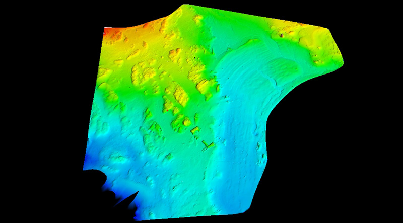
A topographic map of the Polish Polar Station (Hornsund Fjord, Spitsbergen, Svalbard) |
Visit our profile at Google+
Add us to favorites and keep to date with the last news